Systematic Archaeological Survey

The foremost goal of archaeological work is to collect as much information as possible about every historic and archaeological site. Many sites will only be visited once by scientists and it is our responsibility to provide complete and accurate descriptions during the recording process. Since 2002, over five hundred prehistoric sites have been recorded in Range Creek Canyon. For each one we fill out the Utah Archaeological Site Form (UASF) that was established in 2018 to standardize data collection. Prehistoric site types in Range Creek include, rock art, storage sites (granaries, cists, and caches), residential (household structural remains), and artifact scatters. Historic sites are those over 50 years old and can include irrigation features, fences, trail systems, cabins, discarded trash, ranch equipment, rock art, and camp sites. For each site survey crews complete an UASF form, draw a sketch map, GPS site location, sketch artifacts and features as well as photograph key components of the site.
Finding and documenting sites are the primary goals of archaeological survey. Since 2002, the primary task facing archaeologists has been to locate and describe all of the sites (historic and prehistoric) in Range Creek using supervised teams of students and volunteers. To accomplish the daunting task of surveying an adequate sample of the more than 50,000 acres drained by Range Creek, a number of methods have been used. When researchers first entered the canyon they relied heavily on information provided by Waldo Wilcox, the previous owner of the ranch. Mr. Wilcox was able to lead archaeologists to scores of sites he knew about having lived in Range Creek for more than fifty years. At the same time, survey crews chose areas to search based on previous experience, knowing where a site is likely to be located because of topography and proximity to resources. This type of survey is called intuitive or unstructured and it continues to play an important role in investigating the canyon. Since 2004 another method has been used - systematic sampling. In this method a grid is superimposed over a map of the area to be sampled and then random quadrats (or plots) are chosen. The advantage of this method is that it provides a true sampling of the canyon with the goal of using the information to make precise inferences about where sites are located and, just as importantly, where they are not.
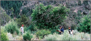
The method we use to survey is for crews walking parallel transects spaced no more than 10-15 meters apart. However, because of the rugged and steep terrain in most parts of Range Creek, some portions of quadrats can not be safely walked. Instead, each crew may use binoculars to look for sites from a distance. Each crew carefully records on a map those areas that have been walked and those that could only be checked from a distance.
Once a site has been discovered the survey crew stops to record it. Work begins by pinflagging each artifact and feature (e.g. pit house, granary, rock art, fire pit). When this is completed, each member of the team goes to work on their assigned task including measuring, mapping, drawing, and recording as much information as possible. Using Global Positioning Systems, site location is determined; photographs are taken of the site, artifacts, and features; and samples are collected, labeled, and packaged.
A representative sample of diagnostic artifacts (radiocarbon samples, projectile points, ceramic sherds, maize cobs, etc.) is collected from the surface of sites for laboratory analyses after the location of each is documented. These samples often provide information concerning when the site was in use and by whom. Following analyses the artifacts are curated at the Natural History Museum of Utah. Some of these artifacts are currently on display at the Natural History Museum of Utah in Salt Lake City, Utah.