University of Utah, Department of Geology & Geophysics
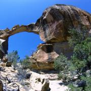
Rocks exposed in Range Creek Canyon are Paleocene to Middle Eocene age (~65-45 Ma), ranging from the Paleocene Flagstaff limestone (exposed at the south end of the canyon) to the Paleocene-Eocene Colton Formation. Eocene Green River Formation is exposed in the Valley Mountain plateau area, above ~2600 m elevation (see geologic map and formation descriptions).
The Sedimentary Geology Research Group at the University of Utah (Department of Geology and Geophysics), under the guidance of Professor Cari Johnson, is studying the geology of Range Creek. Our work currently focuses on defining the transition in depositional systems from the lacustrine Flagstaff limestone, through a basal unit of the fluvial Colton Formation defined by dark red mudstone with laterally discontinuous sandstone channel units, overlain by a thick upper Colton unit of laterally continuous sandstone sheets.
A working hypothesis is that these were generally northward-flowing river systems that prograded over Lake Flagstaff and continued to build out toward the Eocene Lake Uinta to the north (e.g., Nine Mile Canyon area) (Morris et al., 1991). These river systems, which seem to have evolved from lower to higher energy systems over time, likely fed the ‘Sunnyside’ and related deltaic systems on the margin of the lake. The Green River Formation overlying the Colton in this area may represent the major transgression of Lake Uinta across the Douglas arch and into the Piceance Creek basin, beginning at about the ‘middle marker’ horizon of Ryder et al. (1976).
Within this general framework, many questions remain including:
1) What kinds of fluvial systems were these and how and why did they change through space and time?
2) How do these rocks correlate to other well-known sections of Paleogene strata in the area, including the well-studied nine mile canyon area to the north (Keighley et al., 2002; Taylor and Ritts, 2004).
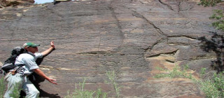
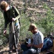
Our work includes measured sections to characterize the stratigraphy and fluvial architecture, as well as ‘Gigapans’ to document lateral and temporal variations (see www.gigapan.org; search for user UU_Geo. See this one, for example).