Using GIS & Integrated Data Systems
Hand Drawn Sketch and Scale Maps
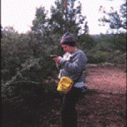
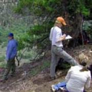
Sketch maps are the quickest way to document the relative location of artifacts and features on an archaeological site. They are also the least accurate method. A hand drawn sketch map is produced for each site recorded in Range Creek Canyon. Students learn to record the location of archaeological features and artifacts on the ground surface in two dimensional space. Sketch maps are quick because they show artifacts and features in relation to each other but the distance between each object or feature is not measured. A sketch map does not have a scale. If the crew has more time, they may draw a scaled map. This requires using a compass and pacing the distance between objects or using a 50-100 meter measuring tape to measure distance. The type of map produced is determined by the crew chief and depends on the time available and the size of the site. View Sketch Map
Global Positioning Systems (GPS)
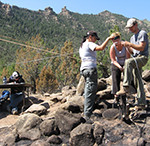
With GPS technology, surveyors calculate their location anywhere on earth using satellite transmitted signals. Hand held GPS receivers calculate positions based on signal travel time from multiple satellites to the receiver. Each survey crew in Range Creek Canyon carries a GPS receiver and an iPad with the ArcCollector App. This allows crews to record the location of each site they discover. Crews can also generate a fairly accurate site map by using GPS locations for each artifact, feature, site boundary, and associated land form. This data can be downloaded on computers in camp. The principal difficulty with using GPS technology in Range Creek is the canyon's steep sidewalls and rough terrain which dramatically limits reception of satellite transmissions. Accurate positions require a clear line of sight from at least four satellites. Thus, the survey crews must often rely on USGS topographic maps and hand drawn mapping techniques.
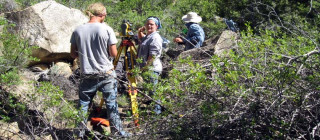
High Resolution Mapping with Survey Grade Equipment
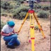
We use a Trimble total station when we need high precision maps, for example if the site will be disturbed through excavation. A total station consists of an electronic theodolite and an electronic EDM (electronic distance measuring). The total station is capable of measuring angles accurately, and it calculates distance by emitting an infrared carrier signal that bounces off a reflector prism (at the location of interest), captures the reflected signal and calculates distance using the known speed of light. Distance and angles are downloaded into a data logger which stores the information until it can be transferred to the computer where the data is stored and visualized using computer graphics. We use the data to create a contour map of the ground surface. The data logger has a theoretical precision of less than a centimeter; but for practical purposes we consider it accurate to about one centimeter. Mapping an archaeological site often requires collecting hundreds, sometimes thousands of points (x, y, z coordinates). Seven sites in Range Creek Canyon have been mapped using the total station, including the field station headquarters (former Wilcox Ranch). View Map
Artifacts
Very few artifacts are collected in Range Creek Canyon. This is because the sites in Range Creek are protected from excessive visitation, construction projects, off road vehicles, etc. We prefer to leave artifacts in place for future study and for visitors to see when they visit this outdoor laboratory. Our collection strategy is only to remove artifacts from the ground surface if they are diagnostic or dateable. When artifacts are removed from the ground surface, they are mapped using a GPS receiver and added to sketch maps. During excavation, all artifacts recovered are collected and curated at the Natural History Museum of Utah.
Data Storage and Retrieval
Tremendous amounts of data have already been collected in Range Creek. Our task is to organize and store this information in a relational database that is easy to access. Information for each Range Creek site is stored in a folder that is linked to the site's location using a spatial database in ArcGIS. The database is updated frequently with the most recent edits generated by staff and students each summer. The linked information includes site forms, photographs, sketch maps, artifact photographs and illustrations, artifact catalogues and analysis forms. When a site is selected from a map in ArcGIS, the database retrieves all the information and displays the images and spreadsheets to assist with early stage exploratory analysis. Staff and students can search the Range Creek database by site number, name and/or type, location, year recorded, land ownership and many other keywords that allow them to group similar sites, detect patterning, and answer questions. The database also displays areas that have been surveyed and areas that still need to be surveyed, which makes for effective planning before each field season. Archaeological data is reported to the federal and state land owners and archived at the State Historic Preservation Office.