
Bill Gray and Mitch Power examine a gnarled juniper branch in the field. © NHMU
How Google Earth Helped NHMU Researchers Preserve Ancient Junipers in Utah’s Henry Mountains
By Michael Mozdy
When emeritus Biology professor Bill Gray, PhD, and NHMU’s Curator of the Garrett Herbarium, Mitchell Power, PhD, began counting juniper tree rings by repurposing Google Earth’s tracking functionality, a short-term win for preserving mature growth stands in Utah was far from their minds.
“First there was the technical challenge of just being able to count superfine tree rings,” recalls Gray, “and then we hoped to date enough samples to get a sense of what’s been happening over the past 1,000 years in terms of climate and growing seasons.”
But in 2022, an opportunity arose to use their technique for a more immediate question. The Bureau of Land Management (BLM) had released a proposal to shred junipers on a 1,000-acre parcel of land in south-central Utah’s Henry Mountains. There has been a longstanding practice of cutting back (and more recently, shredding) junipers for ranching interests. The belief is that the junipers are invasive and take the place of other plants that livestock can graze upon. “Though true in some places it is far from accurate in general,” notes Gray.
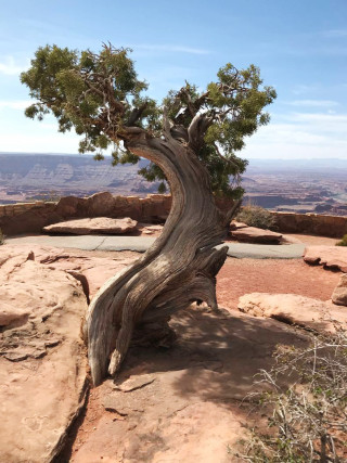
A juniper tree growing at a viewpoint in the Moab region of Utah. © Bill Gray | NHMU
A friend from the nonprofit Grand Canyon Trust contacted Gray about the proposal, wanting to know if the junipers really were young and invasive on this land. The guidelines were 150 years old or less, roughly around the time of modern settlement and disturbance of the landscape. The Grand Canyon Trust believed that these junipers might be older.
Gray visited the site and collected samples. His results astounded everyone: “The oldest I counted was nearly 800 years old,” he says.
Gray and the Trust appealed to the BLM with this data and they cancelled the plan. It was a justifiable, data-driven decision. With around 100 shrubs and trees per acre in the parcel, the 1,000 acres represent a significant amount of carbon sequestration and ecosystem stabilization. “I was happy to find a genuine interest on the BLM’s part to understand the ecosystem and how these plants last so long in such difficult environments,” Gray states.
The Problem with Gnarly Juniper
Most people know that you can tell the age of a tree by counting the rings inside the trunk. Each year, the tree adds a layer of new growth, which over time becomes hardened into a ring discernable from the years before and after. But the technique of looking under a microscope to count rings works primarily for trees that grow in a regular fashion with relatively straight trunks.
When a tree twists and turns as it grows in a shrub-like way, the rings become exceedingly difficult to follow and count reliably.
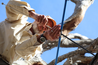
Mitch Power takes a core sample from a juniper tree. © NHMU
“I first became interested in this when hiking in the canyons by the Avenues,” says Gray; “I found some very large shrubs growing in areas too steep for development. I invited Mitch along to look at them. They were so twisted and contorted that there would be no way to take a core sample.” It turned out to be cliff rose. Dr. Power picked up some dead wood, then cut and polished it to reveal an incredibly intricate pattern of rings. They took a high-resolution photograph on which it was easy to count the rings.
Gray began working in the NHMU Botany Lab with Power and one day picked up a juniper sample by accident. It was older and had very, very fine rings. “Many rings are much finer than a human hair,” Gray points out. With this type of growth, it can take over 100 years to grow half an inch in thickness and the very fine rings can be exceedingly hard to count. The implication was quickly apparent: ubiquitous intermountain junipers were likely much older than they looked.
Junipers are, in fact, the most abundant tree in our area. “There are almost certainly over a billion junipers in the intermountain region!” Gray exclaims. Most of these are shrubs, but a fair number are trees, many of which grow in gnarly, irregular ways.
If they were to better understand historical climate in our area and how plants responded, Gray and Power were going to need a better way to count and measure rings.
Repurposing Google Earth
Thanks to a grant from the Burton Family Foundation, Gray and Power constructed a large, moveable table with a mounted high-resolution camera to capture images with striking detail. The setup allows even large slabs of wood to be moved precisely in two dimensions. “We can magnify up to 500 times,” Gray says proudly, “it’s like a big microscope.” At this magnification, an 8-inch diameter tree ring sample is magnified to the size of a football field.
While the setup’s magnification helped them see and count rings, including those finer than a human hair, comparing the width of rings to track historical growing seasons still proved to be a laborious and inexact process. That is, until Gray had a great idea.
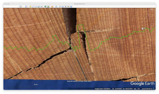
A screen shot from Google Earth shows how its technology is helping NHMU scientists measure tree rings. © Bill Gray | NHMU
“It was one of those ideas that wakes you up at 3 a.m. on a Saturday morning,” he recalls with a laugh. “Tracing a path of wriggly-growing juniper tree rings through a sample is very much akin to what you might do on Google Earth to plan out a trail.”
Developers of Google Earth Pro allow users to put their own picture on the screen and use Google Earth’s tools to examine it. Gray tried this with their tree ring photos and was delighted to find a quantifiable way to track historical growing seasons. By selecting the inner and outer edges of each tree ring, Google Earth can provide Gray with an exact value, which he easily converts to millimeters.
Now the NHMU Botany Lab is working its way through many of their juniper samples to get a statistically robust sample size, allowing Gray and Power to evaluate what types of climatic boom and bust seasons occurred in our region over the past 2,000 years.
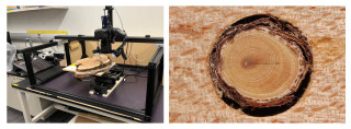
A diptych of the imaging station at NHMU and a detailed photo of tree rings. © Bill Gray | NHMU
More Projects in Sight
Their photography technique is useful for a wide range of projects needing magnification. For instance, they are able to count the tiny pores in leaves called stomata that are essential for transpiration and photosynthesis. Environmental factors greatly impact stomata, and thus better understanding them can in turn shed light on environmental conditions.
Another area of interest to Power is examining lake sediment. Tens of thousands of years of pollen, charcoal, and other sediment lie at the bottom of lakes, and this method allows his team to determine what trees and shrubs existed in particular eras and where they came from.
Power, who leads the NHMU Botany Lab, treasures Gray’s knowledge, ideas, and friendship. “I am lucky I get to work with Bill on these projects,” he says, “he’s an inspiration for everyone in our lab group, and we continue to be amazed by the longevity of ancient juniper forests in Utah.”
Learn more about this research in the News from Our Scientists exhibition on display in the Museum. And you can learn more about botany at NHMU here.
Authors
-

By Michael Mozdy
Michael Mozdy is a writer, traveler, and avid home cook. He wanted to be an archaeologist as a child and somehow ended up with several English degrees instead. Michael is a regular contributor to NHMU's Science Stories, covering a wide variety of topics.
-
By Mitchell Power, Ph.D.
Areas of Expertise Botany, Herbarium Collection Fire and Vegetation History Paleoclimatology, Paleoecology Historical Biogeography Background Mitchell Power, P.h.D., curator of the Garrett Herbarium at the Natural History Museum of Utah, is fascinated with the mechanisms that cause changes in plant communities since the last Ice Age. His research explores the linkages among...


