Explorer Corps Marker: Morgan County
Find the Marker
The Morgan County marker is by the east end of the sidewalk across the river from the base of Devil’s Slide. You can’t miss it! To get there, drive about eight miles east of the town of Morgan on Highway 84.
GPS 41°3’49.1904”N 111°32’50.4168”W
Dig Deeper
Utah boasts so many natural wonders that it’s easy to drive right by them and not even know that they’re there. But if you’re driving along I-84 in Morgan County, keep your eyes open in the vicinity of Powder Hollow. There, off the side of the road, is a geologic marvel called Devil’s Slide.
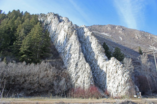
The roadside geology stop doesn’t look like many other rock layers in Utah. The strata that make up the slide are titled vertical, which is quite a geological feat. Following a rule called the Law of Superposition, layers of sediment – that will become rock – are usually laid down horizontally, one on top of the other. This helps geologists and paleontologists tell time in most places. The oldest rocks in a stack will be at the bottom, and the youngest will be at the top.
But there are all sorts of exceptions to this rule. Sometimes the motion of mountains, or the way rocks slip against faults, can change their angle and appearance. And that’s what happened at Devil’s Slide.
The rock layers that make up the Devil’s Slide are primarily made up of what Utah geologists know as the Twin Creek Limestone. These rocks formed about 165 million years ago, about 10 million years before the time of dinosaurs like Allosaurus and Stegosaurus. At the time, what’s now Morgan County was underwater, part of a shallow sea that was teeming with marine life. The limestone that formed in that seaway was eventually buried.
It took some incredible forces to bring the Twin Creek Limestone back to the surface. Around 75 million years ago, a geologic event called the Sevier Orogeny fundamentally changed ancient Utah’s landscape. Mountains were pushed up, and some rock layers where deformed and tilted in the process. The Twin Creek Limestone was among those layers, the dramatic, grinding changes bringing them to a near-vertical position.
Once the Twin Creek Limestone was exposed, erosion could go to work. Water, sun, and wind can all winnow away at exposed rock, but some rock layers are more resistant to erosion than others. Softer rock will usually erode away faster, and harder rock will stick around longer. This is what creates rock overhangs and hoodoos when stone still sits horizontally. In the case of Devil’s Slide, however, the softer rocks were sandwiched in the middle of the harder layers. That’s what gave Devil’s Slide its shape – the softer rocks in the center eroded faster, creating a rut between the harder limestone layers. Even though the slide’s famous for its odd shape, the fact that it exists at all is a testament to just how much the Earth can change given enough time.
Want to Go Farther?
Visit the Natural History Museum of Utah to dig into our state’s geology!