Explorer Corps Marker: Iron County
Find the Marker
The Iron County marker is located at the Parowan Gap visitor’s circle, next to the fee tube and register box. The visitor’s circle is about 11 miles northwest of the town of Parowan on Gap Road.
GPS 37°54’34.0344”N 112°59’3.5592”W
Dig Deeper
Parowan Gap is a place defined by time. Each aspect of this natural gap, in the Red Hills of Iron County, is related to the others – nature, prehistory, geology, and human history all overlain on each other in one of the most remarkable places in the whole of Utah.
Much of what makes Parowan Gap unique – and so special to the people who would later pass through this place – lies in its geology. Much of Parowan Gap is made up of Jurassic rocks that were laid down by dune-covered deserts around 200 million years ago. There are other geologic formations here – such as the Late Cretaceous Iron Springs Formation, which contains dinosaur tracks – but it was the reddish and orange stone of the Jurassic that would play a critical role in the gap’s later history.
The rocks that make up the gap’s sides were not always on the surface. They remained stacked belowground for millions of years. It was only between 100 and 40 million years ago, during an event that geologists know as the Sevier Orogeny, that geologic forces started to push these layers back up, exposing them. Strange as it is to think about, 100 million years ago dinosaurs could walk on top of rock layers that were laid down 100 million years earlier when their early Jurassic relations lived here.
But that’s hardly all. Sometime after 20 million years ago, a stream began to flow over the top of the ancient rock layers. This is what actually created the gap, eroding away a little more each day and each year, until a natural gap in the rock formed. Eventually, climate changes caused the stream to dry up and to stop carving into the stone. And it’s at this point that the human story begins.
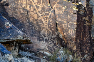
Native Americans inhabited what’s now Utah by about 11,000 years ago, and by 5,000 years ago some of them were moving through Parowan Gap. We know because of the petroglyphs and rock art left behind. The three-mile-long gap includes 90 different rock art panels with almost 1,500 different figures, one of the densest accumulations of rock art known.
The nature of the rock itself made it excellent for making petroglyphs and pictographs. Oxidization stained the faces of the carved Mesozoic rock, creating a dark veneer. As people poked and chipped away at that outer layer, the lighter rock below stood in contrast to the stained stone. And once people started to create these rock art panels, more accumulated through time – a sort of registry left by people who knew this place.
Precisely who left the rock art is sometimes hard to discern. The rock art represents different styles, which are expressions of different cultural groups, going back millennia. The older the art, the harder it can be to categorize. But the Southern Paiute people, who still live here, created some of the more recent art – ties between people, time, and the rock itself.
Want to Go Farther?
Hop out of the car and learn about Parowan Gap through the interpretive signs along the road.