Explorer Corps Marker: Piute County
Find the Marker
The Piute County marker is in the ground between the flag pole and the post office marker at the Piute County Building, located at 550 N Main Street in Junction.
GPS 38°14’42.3744”N 112°13’14.07”W
Dig Deeper
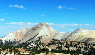
Some of Utah’s geologic wonders are so immense that they’re difficult to see. Marysvale Volcanic Field in Piute County is one such place. Spread around 3,000 square miles, the rocks of this seemingly inconspicuous spot record a trio of megalandslides triggered by the weight of intense volcanic activity.
Between 25 and 20 million years ago, during the end of a time known as the Oligocene and towards the beginning of the following time called the Miocene, volcanoes located in ancient Utah erupted. The dramatic events oozed thick layers of lava and an incredible amount of ash over what is now southwestern and south-central Utah. But, as Dr. Randall Irmis, NHMU's chief curator and curator of paleontology, notes, these eruptions only set the stage for what was to follow.
“The combination of the weight of these very thick volcanic deposits, the residual heat from the rocks once being molten, and the easy-to-break nature of the rocks made by volcanic ash caused three different mega-landslides,” Irmis notes. The rock couldn’t support the weight of all that new, volcanic rock placed on top of it, slipping and sliding with such force that the heat created by the landslides made a strange form of telltale rock called a pseudotachylyte.
The landslides were certainly bad news for prehistoric life in Utah at the time. “I wouldn’t want to be a Miocene mammal living nearby,” Irmis says. The slides moved an incredible amount of rock, not just in terms of extent but of volume. Geologists calculate that the total amount of the slide debris could almost fill the Grand Canyon to the rim.
Despite how old this geological wonder is, though, researchers have only recently recognized how intense the original event was. “Geologists have been studying these rocks for nearly 100 years,” Irmis says, with researchers beginning to suspect something massive by the end of the 20th century, “but the enormity of the situation wasn’t recognized until 2014.”
If all of this sounds a little hard to comprehend, the eruption of Mt. St. Helens in 1980 offers a glimpse at what the aftermath of the Marysvale eruptions might have been like. “Imagine watching millions of cubic tons of solidified lava and volcanic ash suddenly breaking away from hilly slopes and coming towards you at several hundreds miles an hour,” Irmis says. Geology can seem very slow until it begins to move very fast.
But researchers are really only just beginning to understand what happened here. “There’s still a lot to figure out in terms of the original volume and size of the slides,” Irmis says, and notes that research is ongoing. Such sites are very rare and hard to study – mostly because they’re so big! – but geologists rarely let such a fascinating site slide.
Want to Go Farther?
After you find the Piute County Marker, you can visit the Marysvale Volcanic Field. One of the largest volcanic fields in the western United States, it’s a little more than an hour north west of the marker itself and sits south of Interstate 70.